WETLAND CONSERVATION
A CONTEMPORARY APPROACH
A CONTEMPORARY APPROACH
 Aksha Chowdhary
May, 2019
Aksha Chowdhary
May, 2019
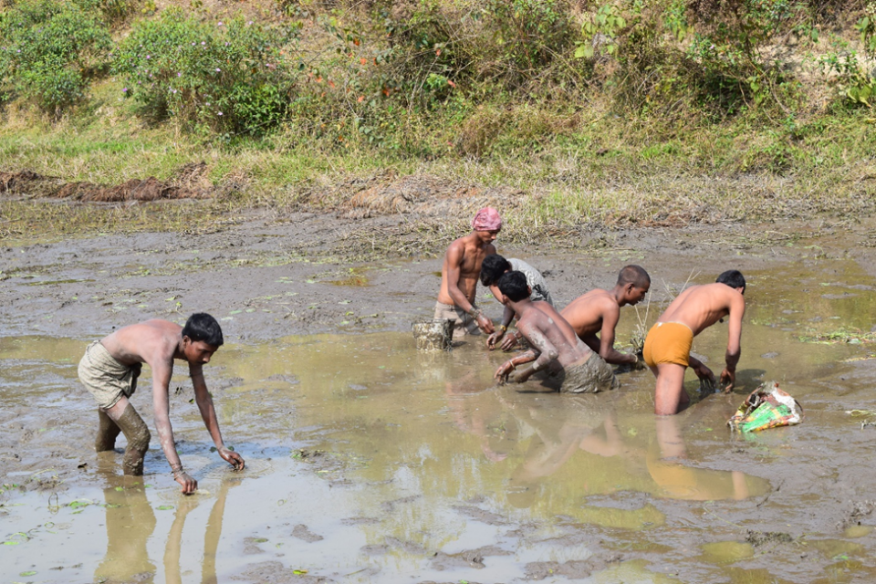
As I stood on the thinning land, barely two steps from the swampy Lotus Blooms I squinted my eyes and tried looking through my Nikon on a foggy December morning. A flock of the highest flying migratory birds heralding from Central Asia, Bar Headed Geese floated at ease. A white throated Kingfisher swooped through the air and lifted the fluttering trophy from the water while nosing off its peer on the boat who was laying nets all around, hoping for a good catch to sell. At some distance was a herd of Buffalos dipped in a mud bath, while a chirpy wader feasted on the ticks off their backs. The daily chores at Bar Beel(Wetland) near Kaziranga National Park(KNP) commenced at full swing. It was one of the largest wetlands, locally known as beel in the area. As the day progressed, the chaos receded. As I waited patiently at the bank hoping for a satisfactory shot, an elite couple of One Horned Rhinoceros walked towards the water, chewing on the soft scented grass, occasionally drinking from the beel. Such was the intricate relationship with Wetlands.
Wetlands are identified as areas where water is the controlling factor, a transition zone between land and water characterized by soils and vegetation that tolerate anaerobic conditions. Wetlands occur globally in every climate and continent except Antarctica. Wetlands serve the needs of many different stakeholder groups. They provide vital services to production systems, including flood and drought regulation, water quality enhancement and storm protection. They deliver valuable products such as fisheries and timber.
India, being the 3rd largest contributor to Fisheries, depends on wetlands for both fish and other aquaculture products like Prickly Lily (Makhana). This ecosystem provides great volume of food that attracts many animal species like shellfishes, small fishes and predatory fishes. Both capture and culture fisheries can be effectively carried out in these type of water logged areas. Moreover, Wetlands act as flood attenuators; temporarily storing storm water before releasing it in the stream, thereby delaying flood and decelerating the rate of discharge. For instance, The Sundarbans, which is a Mangrove Wetland, protects the hinterland from storms, cyclones, tidal surges, and the seepage and intrusion of saltwater inland and into waterways. They serve as nurseries to shellfish and finfish and sustain the fisheries of the entire eastern coast. They have also been named “Tiger Conservation Landscape” of global importance as it supports a significant population of tigers.
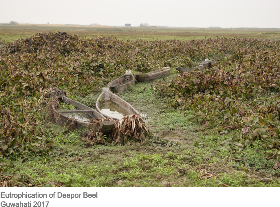
The wetland landscape is changing at a fastidious rate largely due to human interference. They are delicate Ecosystems; minute changes in the pH, temperature or water volume result in noticeable change in native species of flora and fauna jeopardizing the lives of its dependents. The threats looming over wetlands are plenty. Deepor Beel Bird Sanctuary once flourishing with life, is now desolate. It has been identified as an Important Bird Area (IBA) and is a Ramsar Site. Located in the outskirts of Guwahati City, this wetland has conveniently been turned into a Wasteland. On interaction with a local, he said ‘Our nets are filled with plastic and dead fish.’ The continuous dumping of industrial and medical waste contaminates the water, changing its pH which leads to the growth of invasive plant species like Water Hyacinth. The proliferation of these flowers deprive the fish from oxygen supply causing death.In other areas like the ones around Kaziranga National Park, floods bring in a large amount of sediments. Repeated sedimentation may cause a condition known as ‘Ecological Succession’ and soon all wetlands will turn into scrublands and woody forests. Irrespective of the cause, it is important to monitor the large number of wetlands spread across the country and seek urgent solutions to the unique problem each one faces.
With the advent of Space Technology, monitoring Wetlands no longer seems like a Herculean Task. Data acquired by Earth Observation systems cover a wide range of spectral, spatial, and temporal characteristics. Satellite images alone give us enough information about the extent of wetlands along with the health of vegetation and hydrological characteristics. When this data is processed using GIS software, one can routinely prepare reports on changes in Wetland Ecosystems at a much faster pace entailing precautions and corrective measures.
An attempt to extract wetlands from satellite imagery, classify them according to their Hydrological Characteristics and monitor seasonal changes in the ecosystem was made. Kaziranga National Park was chosen as the Study Area.
Extraction of Wetlands from other features in Satellite Images was fulfilled using Object Based Image Analysis. Since water has low reflectance in the Near Infrared Band, an index called Normalized Difference Water Index (NDWI) was used to isolate water pixels. Therefore, a threshold was set to separate water pixels from the satellite image. Next, to separate wetlands from rivers, a geometry threshold was applied since wetlands are compact objects.
After extraction, classification of wetlands was done using Digital Elevation Modelling (DEM) data. A wetland hydrology network can be created using GIS, to understand the hierarchical wetland connectivity to streams; in simple terms their spatial distribution. Since Kaziranga lies in the floodplain of River Brahmaputra, most of the Wetlands lie at an elevation of 55-90m. Using Arc Hydrology tools, a map of water flow was prepared thus giving information about the wetlands which will capture more water than others. Furthermore, if the flow direction and area of each wetland are computed together, one can identify the wetlands that will have highest water retention potential.Hydrological Modelling aids in systematic conservation of wetlands located in flood prone or drought prone areas.
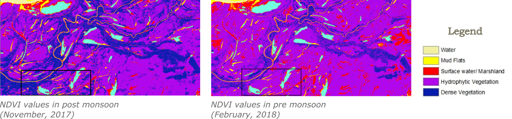
Studying seasonal changes is perhaps the most interesting approach to understand the behavior of wetlands. Hydrophyte vegetation is characteristic of Wetlands and thus can be studied using the Normalized Difference Vegetation Index (NDVI) and Modified Difference Pond Index (MDPI) by utilizing their spectral information. Another Index called Modified Normalized Difference Water Index (MNDWI) was also calculated to study the decrease in depth of water during winters.
Seasonal changes lead to change in the NDVI values in the Wetlands. In the Post Monsoon month of November, high NDVI values are exhibited whereas as the dry spell hits in February/March, the NDVI values show a decrease. Dense vegetation is saturated around the streams and water bodies post monsoon due to high proliferation and density. In February, dense vegetation around water bodies is reduced to scattered or hydrophytic vegetation. In certain areas the surface water is exposed in February with reduction in organic matter.
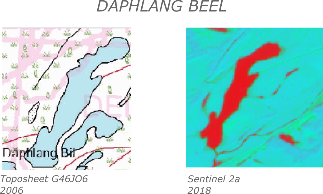
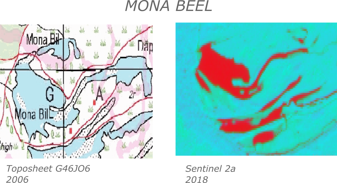
Temporal Changes in Wetlands was also detected by overlaying the Satellite Images of November 2018 on the Toposheet G46J06 prepared in 2006. Reduction in area of 2 important wetlands- Mona Beel and Daphlang Beel has been observed in the last decade. Reason? As documented in a paper by International Science Congress Association, Waste Dumping is listed as the primary reason for loss in Wetland Area in the aforementioned study area. (Pratyashi Phukan and Ranjan Saikia; Wetland Degradation and its Conservation: A case study of some selected wetlands of Golaghat district, Assam, India; ISCA 2014)
To limit human interference in and around Wetlands a Land Use/Land Cover (LULC) Classification could be utilized to understand the inflow and outflow from the Wetland. For example ecosystem services from Wetlands can be utilized to plan an integrated farming system as Wetlands provide fertile soils, fulfils water demand and filters organic agricultural waste. But, if chemical waste, like the ones from tea gardens leach into the Wetlands, it could disrupt the entire ecosystem. Thus, Remote Sensing and GIS can also be utilized to locate non-point pollution sources and impede its inflow into the Wetland.
Conservation of Wetlands has to be given utmost importance considering the rate at which these sensitive eco-zones are being degraded. Since Wetlands are distributed widely across the country in both accessible as well as inaccessible areas, it is important to use the technology of Remote Sensing Data to map and monitor these areas so that a systematic approach can be devised for its conservation. February 2nd has been recognized as World Wetland Day to acknowledge the urgency for conservation of this precious resource. In India, the protection of Wetlands have received increasing attention in a past few years and the use of Geographic Information System has become popular for Wetland Monitoring and Mapping. This systematic approach will prove to be fruitful in the sphere of Conservation and Protection.
Aksha is a student of Geoinformation and Remote Sensing. Apart from dawdling around with the camera in the hope of a jolly capture, she aspires to be a Conservationist with a strong inclination towards Wildlife and its interaction with humans. She has spent time studying Human-Elephant Conflict in Kaziranga, assisting in reptile and bird rescue and organising Awareness Camp about the pressing issues of the Environment. She believes in systematic Conservation and use of both remote sensing and biological technology to protect natural diversity.